Learning Outcomes:
you WILL know where Machu Picchu is & what are its attractions to tourists
you SHOULD be able to explain the impact of visitor numbers, using sub headings social, economic & environmental
you MAY be able to descibe & evaluate management initiatives that have been implemented to manage the site & the impact of tourism.
Produce a piece of work (powerpoint, essay, poster......) that:
illustartes the location & attractions of Machu Piccu
explains how tourism is affecting Machu Piccu
identifes & evaluates attempts to manage the impact of tourism
Good starting points for research (hyperlinks):
UNESCO
Machu Piccu Travel
The Inca Trail & Machu Piccu Virtual Tour
If you choose a powerpoint it should be printed out in note format, 3 slides to a page.
Monday, 31 October 2011

Monday, 24 October 2011
Revising?
If you are re-sitting unit 2 in particular you should be following events around the mediterranean with an earthquake in Turkey & now a
fresh eruption on mt.Etna.
http://t.co/RbWzm9ZL
- Posted using BlogPress from my iPhone
fresh eruption on mt.Etna.
http://t.co/RbWzm9ZL
- Posted using BlogPress from my iPhone
Friday, 21 October 2011
Half term homework
Why does Nepal attract tourists? What impact does tourism have on Nepal?
For Tuesday 1st November. Have a good half term folks! Mrs J.
- Posted using BlogPress from my iPhone
For Tuesday 1st November. Have a good half term folks! Mrs J.
- Posted using BlogPress from my iPhone
Wednesday, 19 October 2011
Machu Picchu
Mountain Tourism & Historic Tourism!
Where? What? How many visitors? What are the management issues? Who goes? How do they get there? Build up a research file!
Where? What? How many visitors? What are the management issues? Who goes? How do they get there? Build up a research file!
Tuesday, 18 October 2011
Homework- historical tourism
What are the most popular historical sites in the UK? What contribution do they make to the tourist industry? Include facts & figures. Include more details about one of them. For Friday.
- Posted using BlogPress from my iPhone
- Posted using BlogPress from my iPhone
Monday, 17 October 2011
Olympic Tourism

OK folks, Geographylost is back in business!
Research Essay: What might the effect of the London Olympics be on Tourism in the UK in 2012. Consider both the advantages & disadvantages of hosting a major event on the tourist industry. Refer to the effects of other major events as well as speculation & studies about 2012.
Note sources & include pictures/ statistics/ copies of adverts..... You will need to refer to a range of sources to provide a balanced answer.
The learning outcomes are:
WILL be able to list some of the possible impacts of the London Olympics to the Tourist Industry in the UK
SHOULD be able to explain what these effects may occur
MAY be able to use the experience of other Olympic Games (or major events) to support your answer
Try & include a source that could form part of a data response question on event tourism & include it (e.g. graph of tourist income in Sydney in 2000 compared with a non-Olympic year.
The task should be completed using WORD or PUBLISHER.
Sunday, 15 May 2011
Revision sessions
Coasts:
Thursday 19th May
Wednesday 25th May
Tuesday 7th June
Hostile World:
Thursday 16th June
ALL are 3.30 until 4.30, rm 2
People re-taking Coasts are VERY STRONGLY recommended to attend as many sessions as possible!!!!!
Tropical Storm Case Studies
The wonderful Hurricane Song is here! Factually all correct, even if it does hurt your ears!
Essential information on Hurricane Katrina can be found here
Hurricane Mitch -hit Central America & created killer landslides. Very heavy rainfall. Check here for more details.
Essential information on Hurricane Katrina can be found here
Hurricane Andrew was only the third category 5 Hurricane to make landfall in the USA & most of its damage was caused by the wind, making an interesting contrast with the other two tropical storms included here. This site gives a good overview of the behaviour & impact of the storm. Make suitable notes to enable you to make comparisons with Hurricane Katrina, Hurricane Mitch & Hurricane Hanna (the one in the text book).
Monday, 21 March 2011
Tropical Storms Lesson Two
Tropical Storms Lesson Two is here for those absent on work experience. There is no expectation that you do the work but you might like to look through what was done in the lessons.
Tropical storms lesson 2
View more presentations from jacksonthree.
Wednesday, 16 March 2011
Hurricanes 18/03/2011
Start to review & develop your understanding of Hurricanes using BBC Bitesize. Click here to go to the correct website. You must be able to explain in detail how a hurricane is formed. You must be able to draw the diagram showing the cross section of a hurricane. You should work through 'revise' & then go onto the videos & test sections. Ask the cover teacher for headphones when you need them & do loads of work. You need thorough notes in your books! Look at links on the side bar to other pages on Hurricanes.
Those on work experience may wish to read through the stuff.
Those on work experience may wish to read through the stuff.
Tuesday, 1 March 2011
Safer City: Using Google Earth
Start by clicking on this link to load the Safer City Google Earth file. Have a good look around San Fransisco- click on the panoramas & webcams. Then have a look at the layer features, such as the 3-D buildings & terrain.
The next step is to look at the project layers which show the fault lines, the areas in danger from liquifaction & landslides. There is a live link to recent earthquakes.
Your task is to choose the safest location for a new hospital. Use a screen dump to produce a map & annotate it to explain your choice.
The next step is to look at the project layers which show the fault lines, the areas in danger from liquifaction & landslides. There is a live link to recent earthquakes.
Your task is to choose the safest location for a new hospital. Use a screen dump to produce a map & annotate it to explain your choice.
Tuesday, 1 February 2011
Wednesday 2nd Feb

What you need to be able to do by the end of the lesson is to know the difference between Primary and Secondary hazards associated with volcanoes.You should be able to recall a range of hazards associated with specific volcanic eruptions.
You should have loads of opportunities to evidence good research skills!
You first need to decide & record in your books the different types of hazards associated with volcanic eruptions. This needs to be a fairly specific list (e.g. if you have not mentioned lahr flows its not good enough!)
Then go onto this website which is a starting point for studying the recent volcanic eruption of Eyjafjallajokull in Iceland. Identify the primary hazards associated with this eruptive event. How did the affect a) the people b) the landscape? Name one secondary hazard associated with this eruption? How can you measure its impact? Write up the work in your exercise books. Feel free to stick in any material you find useful.
COMPLETE ALL TASKS BEFORE FRIDAY'S LESSON. Books will be collected in!
Keep a list of websites you have used.
Tuesday, 25 January 2011
Tectonics Tourist: Lesson 26th January 2011
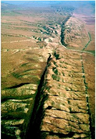
Complete a page for a tourist travel book for a geologically interested person to visit ONE of the following plate margin locations:
Iceland
The Red Sea
Washington State, USA
Phillipines
Tibetan plateau
California
The page must contain the following:
A location map
Pictures
Details of the plate margin & movement at that location
Details of any tectonic events within the last 30 years.
It should be printed off & stuck into your exercise books.
This website provides a good summary of the different types of plate margins
Thursday, 20 January 2011
Hostile World
There are three key questions in this unit:
Key Question: What are the causes and effects of earthquakes and volcanic eruptions and how do people prepare for and respond to them?
Key Question: What are the causes and effects of tropical storms and how do people prepare for and respond to them?
Key Question: What are the causes and effects of wildfires and how to people prepare for and respond to them?
The Unit 2 exam is in June!
Key Question: What are the causes and effects of earthquakes and volcanic eruptions and how do people prepare for and respond to them?
Key Question: What are the causes and effects of tropical storms and how do people prepare for and respond to them?
Key Question: What are the causes and effects of wildfires and how to people prepare for and respond to them?
The Unit 2 exam is in June!
Friday, 17 December 2010
Links for Year 9 revising for January exams

The following weblinks will be invaluable when revising for your January Trial Exam:
Make sure that your revision is ACTIVE! make flash cards, mindmaps, posters, games (use http://www.classtools.net/ to make 'arcade style' revision games), PowerPoints. Use BBC Bitesize to test your knowledge & understanding.
You need to know:
What causes earthquakes, Where earthquakes happen, Kobe Earthquake (MEDC) & Haiti Earthquake (LEDC). Make sure you learn KEY TERMS & know the case studies in detail.
Tuesday, 30 November 2010
Some useful revision links
Ready to revise?
Kent Coastal management Download this document. Save it... read it...!
This is a really useful link!
Don't forget BBC Bitesize or use this or this to revise the Holderness Coast.
Remember to make your revision ACTIVE not passive!
Kent Coastal management Download this document. Save it... read it...!
This is a really useful link!
Don't forget BBC Bitesize or use this or this to revise the Holderness Coast.
Remember to make your revision ACTIVE not passive!
Monday, 22 November 2010
Games & Challenges to aid revision!
These have been created by Year 10 for Year 10 whilst revising for Module 1. Click on the hyperlinks to go to the puzzle or games. More to come soon!
Matching Pairs
Manic Miner or other arcade games
Fruit Machine to help test key terms
Coastal Erosion Crossword
Matching Pairs
Manic Miner or other arcade games
Fruit Machine to help test key terms
Coastal Erosion Crossword
Saturday, 6 November 2010
Coral Reefs
Sorry I am a little late posting the homework! Watch this video clip please. The final written task is at the foot of the post.
The Great Barrier Reef Marine Park is a multiple-use area. It covers 344,000 square kilometres. Zoning helps to manage and protect the Marine Park so that all users can enjoy it, now and in the future. Zoning therefore helps to make sure that the Park is managed in a sustainable way.

Zoning Plans say what activities can happen where, both to protect the marine environment and to separate potentially conflicting activities. The current Zoning Plan was introduced in 2004.
The Preservation Zone - the Pink Zone - is a 'no go' area. A person cannot enter a Pink Zone unless they have written permission and extractive activities (eg. removing coral or fishing) are strictly prohibited. Research may occur in a Pink Zone, if it cannot be done elsewhere, but only if the research is relevant to, and a priority for, management. A permit is required to conduct research in this zone. The Pink Zone makes up less than 1% of the Great Barrier Reef Marine Park. Pink Zones provide high-level protection for special and unique places, habitats, plants and animals within the Marine Park and provides an undisturbed baseline for comparison with other zones.
The Marine National Park Zone - the Green Zone - is a 'no-take' area and extractive activities like fishing or collecting are not allowed without written permission from Marine Park authorities. Anyone can enter a Green Zone and participate in activities such as boating, swimming, snorkelling and sailing. Fishing gear, such as rods with attached hooks, must be stowed inboard the boat or in rod holders. All fishing apparatus must be out of the water. Anchoring is also allowed in a Green Zone, however in high use and sensitive areas use of a mooring may be necessary or there may be a no anchoring area defined by buoys. The Green Zone makes up about 33% of the Great Barrier Reef Marine Park.
Green Zones protect the biodiversity within the Great Barrier Reef Marine Park by protecting important breeding and nursery areas such as seagrass beds, mangrove communities, deepwater shoals and reefs. The size of fish within no-take areas will increase and these bigger fish will produce more offspring. Adult fish and their offspring are not confined to the no-take areas and can move into adjacent areas, creating a spillover effect that helps replenish fish stocks in areas where fishing is allowed.
The Scientific Research Zone - the Orange Zone - makes up less than 1% of the Park. It facilitates research, in areas primarily around scientific research facilities that are relatively undisturbed by extractive activities. The Orange Zone helps to manage research activities and separates research from conflicting, high impact activities. This helps to ensure research and data gathered within the Great Barrier Reef Marine Park is less influenced by human activity.
The Buffer Zone - the Olive-Green Zone - makes up about 3% of the Park. It provides for the protection and conservation of areas of the Marine Parks in their natural state, while allowing the public to appreciate and enjoy the relatively undisturbed nature of the area. Trolling for pelagic fish species is allowed in the Buffer Zone. However, all other forms of extractive activities such as bottom fishing and spearfishing are prohibited in this zone. Pelagic species include species of trevally, scad, queenfish, rainbow runner, dolphinfish, black kingfish or cobia, barracuda, sailfish, marlin, swordfish, mackerel, tuna, bonito, wahoo, small toothed jobfish and green jobfish.
The Conservation Park Zone - the Yellow Zone - allows for increased protection and conservation of areas of the Marine Park, while providing opportunities for reasonable use and enjoyment including limited extractive use. Most extractive activities are allowed in a Yellow Zone with additional restrictions for most fishing activities. Fishing activities allowed in a Conservation Park (Yellow) Zone include:
- limited line fishing (one hand-held rod or one hand-held line per person, with no more than one hook attached to that line)
- trolling (no more than three lines per person and up to six hooks combined total per person)
- limited spearfishing (snorkel only)
- bait netting
- limited crabbing (four crab pots, dillies or inverted dillies)
- limited collecting (includes oysters and bait, excludes take of coral (live or dead and anemones)
The Habitat Protection Zone - the Dark Blue Zone - provides for the conservation of areas of the Great Barrier Reef Marine Park by protecting and managing sensitive habitats and ensuring they are generally free from potentially damaging activities. Trawling is not permitted in the Habitat Protection Zone. The Zone continues to provide for reasonable use of areas and makes up about 28% of the Great Barrier Reef Marine Park.
The General Use Zone - the Light-Blue Zone - is to provide opportunities for reasonable use of the Great Barrier Reef Marine Park, while still allowing for the conservation of these areas. The General Use Zone in the Great Barrier Reef Marine Park is very similar to the Queensland (State) General Use Zone.
The Queensland Government manages commercial fishing in the Marine Park. The main management strategies are:
- limits on the number of fishing licences
- seasonal closures
- restrictions on the size of fishing boats
- restrictions on the length, mesh sizes and number of nets used
- limits on the number of hooks used
- limits on the numbers of traps such as crab pots used
- limits on the total allowable catch restrictions on the size of fish
Many organisations are researching the impacts of the zoning of the Marine Park.
TASK: Watch this video clip & answer this question
'How effective is the management of the Great Barrier Reef in protecting the reef area?' (6 marks)
The Great Barrier Reef Marine Park is a multiple-use area. It covers 344,000 square kilometres. Zoning helps to manage and protect the Marine Park so that all users can enjoy it, now and in the future. Zoning therefore helps to make sure that the Park is managed in a sustainable way.
Zoning Plans say what activities can happen where, both to protect the marine environment and to separate potentially conflicting activities. The current Zoning Plan was introduced in 2004.
The Preservation Zone - the Pink Zone - is a 'no go' area. A person cannot enter a Pink Zone unless they have written permission and extractive activities (eg. removing coral or fishing) are strictly prohibited. Research may occur in a Pink Zone, if it cannot be done elsewhere, but only if the research is relevant to, and a priority for, management. A permit is required to conduct research in this zone. The Pink Zone makes up less than 1% of the Great Barrier Reef Marine Park. Pink Zones provide high-level protection for special and unique places, habitats, plants and animals within the Marine Park and provides an undisturbed baseline for comparison with other zones.
The Marine National Park Zone - the Green Zone - is a 'no-take' area and extractive activities like fishing or collecting are not allowed without written permission from Marine Park authorities. Anyone can enter a Green Zone and participate in activities such as boating, swimming, snorkelling and sailing. Fishing gear, such as rods with attached hooks, must be stowed inboard the boat or in rod holders. All fishing apparatus must be out of the water. Anchoring is also allowed in a Green Zone, however in high use and sensitive areas use of a mooring may be necessary or there may be a no anchoring area defined by buoys. The Green Zone makes up about 33% of the Great Barrier Reef Marine Park.
Green Zones protect the biodiversity within the Great Barrier Reef Marine Park by protecting important breeding and nursery areas such as seagrass beds, mangrove communities, deepwater shoals and reefs. The size of fish within no-take areas will increase and these bigger fish will produce more offspring. Adult fish and their offspring are not confined to the no-take areas and can move into adjacent areas, creating a spillover effect that helps replenish fish stocks in areas where fishing is allowed.
The Scientific Research Zone - the Orange Zone - makes up less than 1% of the Park. It facilitates research, in areas primarily around scientific research facilities that are relatively undisturbed by extractive activities. The Orange Zone helps to manage research activities and separates research from conflicting, high impact activities. This helps to ensure research and data gathered within the Great Barrier Reef Marine Park is less influenced by human activity.
The Buffer Zone - the Olive-Green Zone - makes up about 3% of the Park. It provides for the protection and conservation of areas of the Marine Parks in their natural state, while allowing the public to appreciate and enjoy the relatively undisturbed nature of the area. Trolling for pelagic fish species is allowed in the Buffer Zone. However, all other forms of extractive activities such as bottom fishing and spearfishing are prohibited in this zone. Pelagic species include species of trevally, scad, queenfish, rainbow runner, dolphinfish, black kingfish or cobia, barracuda, sailfish, marlin, swordfish, mackerel, tuna, bonito, wahoo, small toothed jobfish and green jobfish.
The Conservation Park Zone - the Yellow Zone - allows for increased protection and conservation of areas of the Marine Park, while providing opportunities for reasonable use and enjoyment including limited extractive use. Most extractive activities are allowed in a Yellow Zone with additional restrictions for most fishing activities. Fishing activities allowed in a Conservation Park (Yellow) Zone include:
- limited line fishing (one hand-held rod or one hand-held line per person, with no more than one hook attached to that line)
- trolling (no more than three lines per person and up to six hooks combined total per person)
- limited spearfishing (snorkel only)
- bait netting
- limited crabbing (four crab pots, dillies or inverted dillies)
- limited collecting (includes oysters and bait, excludes take of coral (live or dead and anemones)
The Habitat Protection Zone - the Dark Blue Zone - provides for the conservation of areas of the Great Barrier Reef Marine Park by protecting and managing sensitive habitats and ensuring they are generally free from potentially damaging activities. Trawling is not permitted in the Habitat Protection Zone. The Zone continues to provide for reasonable use of areas and makes up about 28% of the Great Barrier Reef Marine Park.
The General Use Zone - the Light-Blue Zone - is to provide opportunities for reasonable use of the Great Barrier Reef Marine Park, while still allowing for the conservation of these areas. The General Use Zone in the Great Barrier Reef Marine Park is very similar to the Queensland (State) General Use Zone.
The Queensland Government manages commercial fishing in the Marine Park. The main management strategies are:
- limits on the number of fishing licences
- seasonal closures
- restrictions on the size of fishing boats
- restrictions on the length, mesh sizes and number of nets used
- limits on the number of hooks used
- limits on the numbers of traps such as crab pots used
- limits on the total allowable catch restrictions on the size of fish
Many organisations are researching the impacts of the zoning of the Marine Park.
TASK: Watch this video clip & answer this question
'How effective is the management of the Great Barrier Reef in protecting the reef area?' (6 marks)
Tuesday, 19 October 2010
More on Happisburgh
Learning Outcomes
You will have responded to the comments in your book & completed the crossword to review your learning. Have you met the targets you set?
You should have completed additional research on Happisburgh...... collect headphones & watch this video and this video. Watch this news clip. Complete any additional research you think you require to answer this question:
Answer this question in your exercise book ' What is the effect of the policy of managed retreat on the village of Happisburgh?'
Wednesday, 6 October 2010
Action. Points
Learning outcome; i will have reflected upon & improved my knowledge & understanding of key concepts.
Spend at least 15 minutes responding to the 'action point/s' highlighted in your books.
Print off your illustrated essay or PowerPoint (at no more than 2 slides per page, using handout form) & hand in.
Stick in all loose sheets!
Tick off topics already covered from summary sheets
*h/w from yesterday is for next Tuesday!
- Posted using BlogPress from my iPhone
Spend at least 15 minutes responding to the 'action point/s' highlighted in your books.
Print off your illustrated essay or PowerPoint (at no more than 2 slides per page, using handout form) & hand in.
Stick in all loose sheets!
Tick off topics already covered from summary sheets
*h/w from yesterday is for next Tuesday!
- Posted using BlogPress from my iPhone
Subscribe to:
Posts (Atom)
Must have a map!
