Thursday, 13 December 2007
Wednesday, 12 December 2007
Preparing to revise Tectonics!

Tectonic Activity: This is what the specification includes! 'Traffic Light' your learning!
The Earth’s crust is unstable and creates hazards.
Global distribution of continental plates.
Tensional and compressional margins.
The processes of plate movements should be understood and their role in the formation of fold mountains, earthquakes and volcanoes. Include characteristic features and formation of fold mountains, earthquakes (focus, epicentre) and volcanoes (composite and shield volcanoes).
Occurrence and measurement of earthquakes.
The interaction between people and the environments and hazards created by tectonic activity.
Description and explanation of human activity in one range of young fold mountains.
Study of one range of fold mountains e.g. tourism, farming, and HEP in the Alps or Rockies.
Case study of effects and responses to a volcanic eruption and an earthquake to include primary and secondary effects and the short medium and long term responses.
Two case studies are required, a volcanic eruption e.g. Montserrat and an earthquake eg. Kobe. Study to include the short, medium and long term responses of different interest groups e.g. local and national government, aid agencies etc.
Settlement issues in areas of tectonic activity – the advantages and disadvantages of settlement in areas of tectonic activity. Students should appreciate that areas affected by tectonic activity present both advantages and disadvantages for settlement e.g. the threat of a volcanic eruption versus the fertile soils for farming as on the slopes of Mount Etna or the threat of avalanches and difficulty of communications versus the valuable minerals able to be mined in the Andes mountains.
Variations in the effects of and responses to tectonic activity between rural and urban areas, and between MEDCs and LEDCs. A consideration of the values and attitudes of different interest groups.
Choice of earlier case studies from both an MEDC and LEDC will make it easier for students to appreciate these variations. Consideration may be given to differences in population densities, building materials, availability of emergency services, quality of communication networks, relative wealth etc. Values and attitudes to tectonic activity may include the unwillingness of some people to accept the hazard or the need to use the fertile soils through to those who would advise abandonment of areas prone to tectonic activity.
Tuesday, 4 December 2007
Year 8: Land Use in Leeds
-sorry Year 11, this isn't for you!
These are the transects:
Transect One: Along the A58 from Wetherby via Collingham, Bardsey, Slaid Hill,Easterly Road area, Harehills to Leeds City Centre.
Transect Two: Along A64 (York Road) from the A1 (Bramham crossroads), via Seacroft, Cross Gates, Killingbeck, Burmantofts to Leeds City Centre.
Transect Three:From Harewood, along the A61, Alwoodly, Moor Allerton, Chapel Allerton, Chapletown to Leeds City Centre.
Transect Four: From Bramhope, along A669, via Adel, Weetwood and Headingley to Leeds City Centre.
Transect Five: From Menston, along A65, via Guiseley, Horseforth and Kirkstall to Leeds City Centre.
Transect Six: From Stanningley, via Pudsey, then A645 to Wortley & Armley to Leeds City Centre.
Transect Seven: A6110 from Morley via Churwell and Beeston to Leeds City centre
Transect Eight: A639 from Oulton via Hunslet to Leeds City Centre.
For your transect produce a series of PowerPoint slides. Each slide should be a 'collage' of pictures, call outs, adverts ........ showing the land use of a location along the route. The call outs may contain some facts & figures. Adverts could include adverts for shops in the location. The pictures should represent a range of land use including roads, parks, houses & industries as well as shops and services. You may wish to add text in the form of newspaper headlines.
The following websites may be useful (in addition to 'googling' the place name -add 'Leeds' after the name):
Yorkshire Post
Wetherby News
Up my street
Leeds City Council
BBC Where I live -Leeds
I will put a link to this post in the side bar.
Sunday, 25 November 2007

Thursday, 22 November 2007
Tuesday, 20 November 2007
Exercise in Corrie Appreciation!
Complete for next lesson.
Click on this link to watch 'Ice' based on Bill Bryson's work from the 'History of Nearly Everything'. You can watch it direct or download it but be warned, It is a very long download. It is interesting & in my opinion, well worth watching.
All Iced Up: Glaciation

This is what the spec. states for the required learning:
Freeze thaw and the processes of erosion – abrasion and plucking. The characteristics and formation of corries, aretes, pyramidal peaks, glacial troughs, ribbon lakes, hanging valleys, truncated spurs, boulder clay/till, moraines and drumlins.
Recognise and describe glacial features on Ordnance Survey maps and photographs The human uses of an upland glaciated area to include farming, forestry and tourism. The social, environmental and political issues currently affecting upland glaciated areas and the management strategies for contemporary issues re conservation and sustainability e.g. grants for conservation, Stewardship schemes, repair and maintenance of footpaths, eco-friendly new developments as examples of contemporary solutions. The conflicts that arise out of the values and attitudes of different interest groups in upland glaciated areas.
One case study e.g. the Lake District, Alps, Rockies, Himalayas is advised to enable students to describe and explain the human uses of the landscape in upland glaciated areas.
Great stuff!
Wednesday, 14 November 2007
Energy Consumption and Pollution
This is the powerpoint from today's lesson -looks a little different as I have used a different 'host' for the document. Scroll down the sidebar to view.
Sunday, 11 November 2007
Year 8 GCSE Humanities groups
This blog has been running really successfully for nearly a year. The blog has had a very specific aim, that is to support my GCSE Geography groups. The posts either include material used in the lesson so that students can have another look at them & possibly make their own copies for revision purposes or they support additional work to be undertaken by the students. Some of the posts will be of use to Year 8 students, especially those with high target grades & I will label such posts for Year 8 as well as Year 11. In addition I have created a special 'sidebar' for links to materials that are useful/ important just for Year 8 so that they will be easy for you to find. You will be told if material is on the blog. It would have been great to do a blog just for you but..... there ARE only 24 hours in my days!!!!!
Knabs Ridge Windfarm
What are the arguments for and against windpower?  The first three turbines from the controvisal Knabs Ridge windfarm, just to the west of Harrogate are now clearly visable & a little photo shoot by Mrs J on Saturday shows you what it looks like.
  The Powerpoint looks at the issues surrounding the windfarm & forms the basis of the lesson.
  Look up other proposed windfarms, such as the offshore windfarm proposed at Redcar, close to the River Tees estuary or the huge Isle of Lewis windfarm in the Scottish Islands, as well as the Hook Moor windfarm near Wetherby.
The first three turbines from the controvisal Knabs Ridge windfarm, just to the west of Harrogate are now clearly visable & a little photo shoot by Mrs J on Saturday shows you what it looks like. The Powerpoint looks at the issues surrounding the windfarm & forms the basis of the lesson. Look up other proposed windfarms, such as the offshore windfarm proposed at Redcar, close to the River Tees estuary or the huge Isle of Lewis windfarm in the Scottish Islands, as well as the Hook Moor windfarm near Wetherby.Friday, 9 November 2007
Learning Targets
Choose at least two 'Learning Targets' based from this list of 'Knowledge and Understanding' objectives:
Use geographically terminology correctly
Explain key ideas in detail (within an extended piece of writing)
Explain key ideas, justifying a point of view
Describe and explain key ideas
Make effective use of case studies
You may make the target more specific where it is appropriate (e.g. ..... when answering data type questions) or ....in Rivers....
You may express targets in your own words.
You may identify one additional 'organisational' target if appropriate.
Enter them in your planner (around p 20???)
You will be expected to complete a more detailed PDSA exercise in the lesson. The hyperlink will take you back to an earlier post on this. It is vital that you consider WHAT you are going to do to meet the target set! 'Try harder' doesn't promote change!
Tidal surge 'poses grave danger'.

Follow the news as a tidal surge threatens to flood parts of Eastern England.

Follow this link to the BBC news site.
Sunday, 4 November 2007
New Learning!
Well done to all of you for meeting the coursework deadline! Work now begins on the second part of the 'Managing Resources' unit!
The deadline for the leaflet (ILA task) is Wednesday.
The deadline for the leaflet (ILA task) is Wednesday.
Friday, 2 November 2007
Managing Energy Resources
 You already have the 'Learning outline' for this module, which will be our focus for the next three to four weeks (depending on how quickly you 'get it'!). This is a 'learning record' for this part of the Managing Resources module. Use a copy of the record to monitor & check your learning.
Tuesday, 23 October 2007
Coursework: More online help
Your coursework should be nearing completion!!!! Use this powerpoint as a final check (or to help you if you are stuck or unsure!). Remember that it MUST be complete by Friday Nov. 2nd.
Sunday, 14 October 2007
Use your time well!
You should all be in a position to now complete your assignments/ coursework. If you need maps they are in the box in room 48. You can come along to room 48 on Thursday or Friday lunchtime to ask about any problems or if you want your hypothesis 3 title checking (or mention it during the parents evening appointment). See me on Thursday morning if you need a parents evening appointment. I will be somewhere around the Year 11 area/ office. The deadline is 1.00 lunchtime on Friday 2nd November, delivered to room 48 & signed off by yourself!
Wednesday, 26 September 2007
Wednesday, 19 September 2007
Pathway to success!
Well done to all of you who took part in the Celebration evening last night. Build on the success of Year 10 & you will have a great year. The class of 2008 will be fantastic!
Tuesday, 18 September 2007
Kenya
Why do tourists visit Kenya? What impact might this trip have? On the environment? On people? On the economy? Good or bad?
Create a model set of case study notes & learn carefully.
Wednesday, 12 September 2007
Grassington Maps
I have uploaded all of the maps here. They have been scanned & saved into one word document. Copy what you need into a fresh word document or whatever you require. I will sort out how to orientate the surface graph using Excel. If you want to do coursework at lunchtime them Wednesday is the 'formal' workshop day, but one of the Geography teachers is usually in room 48 at lunchtime, so pop along.
Tuesday, 11 September 2007
The class of 2008: Coursework!

The data & some of the maps required for the Grassinton coursework completion are available on K drive & by following these links to 4shared.com, which is a file sharing site.
environmental quality data tuesday
maps (some)
Let me know if you have problems with any of the links or data sets.
We will re-afirm deadlines in the lesson.
Thursday, 23 August 2007
Fantastic!
Just in case anyone should call in here, well done! The GCSE Geography results are the best in school in terms of a*-c grades, and they are the best GCSE results overall that the school has ever had!
Wednesday, 27 June 2007
Time to move on!
The class of 2007 have left -hopefully most will return to do A level Geography in September -and it is now time to do a little housekeeping & re-establish the blog as a place to support quality learning in Geography for a new cohort of students. This is a welcome to the group I will inherit from the wonderful Mrs R. who goes on leave to produce a new little geographer!
All of the 'posts' to date refer to our 'old' EDEXCEL A specification, however many of the them will be relevent to your learning & so will stay & may be linked to. You are encouraged to visit often! I will post at least twice a week, linking to the lessons & at other times. Documents (WORD & Powerpoint) will be available via links to 4shared.com or slideshare.net & you are welcome to make your own copies to support your learning.
I will occasionally set homework based upon material or links posted on the blog & if I am ever absent I will support the sub lesson with a blog post. Develop a blogging habit!Explore the other Boston Spa Geography blogs & some of the other fantastic Geography blogs that exist.
Sunday, 17 June 2007
Leavers Celebration Class 2007
All of the photos I took & have downloaded can be found here: (http://www.flickr.com/photos/sue_jackson/sets/72157600379477650/) I will add more later! There are just under 100 at the moment, but I don't have any of the ballon launch or the final assembly. Spread the word!
Saturday, 16 June 2007
A last word!
If any of my GCSE group read this..... I hope you had a great Leavers Celebration. I really enjoyed putting it all together for you all. I just spotted the comment on the last post! Thank you! If any group was going to sing happy birthday to me I am glad it was you! You have been an absolute pleasure to teach. I hope that many of you do continue to study Geography next year, but if you don't, remember you can never escape...... 'Geography is everywhere', infact 'You would be lost without it!'. I will add the link to the Celebration Day photos when I have downloaded them to Flickr. Thank you. Mrs J.
Tuesday, 5 June 2007
Countdown to paper 2
Check these out!
Not too sure about the tune but good to review the Mt Pinatubo case study (volcanic activity, LEDC).
There are movies relating to the Kashmir Earthquake (earthquake activity, LEDC) linked to earlier in the blog.
Try this to review Mt St Helens (& of course listen to 'ole St Helens'
This is a very stark reminder of the short term impact of the Kobe Earthquake (MEDC quake)
Sunday, 3 June 2007
Revision Breakfast!

Don't forget -from 7.30 onwards in Room 48, we provide the food. Get into the 'geography way' for a flying start to Paper 1!
Check out Mr White's Revision guides on 'Mr White does Geography' -see link at the side!
Tuesday, 22 May 2007
Its coming to an end!

Very best wishes to you all. You deserve your target grades (or higher). Thank you! Hope to see many (most?) of you in AS Geography! Don't forget the Revision Breakfast on June 4th (from 7.30). We provide the breakfast! Mrs J
Tuesday, 15 May 2007
Paper One Case Studies.....again!
These are the specific named examples that you need to know for Paper One
........Physical World = none!
Human World = Leeds & Rio de Janerio.
Economic World the agriculture case studies are Bradley Farm, as an example of agricultural change within the EEC and of course, Intensive Rice Farming in South East Asia! For the industrial location examples we studied the M4 corridor (with Swindon in detail) & Dyson. Natural World: Deforeststion in Paupa New Guiniea.
Look at the specific blog posts on all of these to help with learning these case studies.
Friday, 11 May 2007
Growth of a tourist resort: Aspects of theory
Not my work! Covers the stuff on the growth of a tourist resort really well! Thanks Rich!
More information on Yosemite
Look at this CNN report for some of the issues. The Barcelona Field Study centre site is also worth a look. The Yosemite Falls project gives details of a specific scheme & includes impact details that can be easily summarised.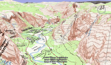
Kashmir Earthquake
Need to know: Cause of the quake, short & Long term impact, short & long term management strategies & issues
Wednesday, 9 May 2007
What do you need to know? Ayia Napa
The impact that tourism has had on people and their environment in an MEDC Ayia Napa, Cyprus
• Located on the south coast, in Greek territory, near the dividing line with the Turkish section of Cyprus.
• Tourist numbers have risen steeply – from 47,000 in 1975 to 2.25 millions in 2000
• In 1988 tourist income estimates at £880 millions
• Cyprus Tourist Office has encouraged this growth, including resorts becoming specialist – Ayia Napa is a young person’s resort
• Climate here is 30 deg C in August with just 10mm of rain, in January 17 deg. C & 75mm of rain
• Ayia Napa is a purpose-built resort, catering for young people
• Nearby waterpark opened 1996
• Nearby marine park – swimming with dolphins
• Local historical and archaeological features
• Tourism in Cyprus provides 20% of GDP (income) and employs 40,000 people.
• In winter hotel occupancy is down to 30%, so the CTO is trying to promote the island for all seasons
• Local people have moved away from the noise and bad behaviour to a site at the top of the hill – leaving their home village to the tourists
• Massive building programmes have changed the nature of the area and put a strain on services, such as sewage and electricity
• Developments have threatened beach turtle habitats and they have moved away
• CTO trying to market island for agro-tourism (sustainable), golfing. Conference and business destinations, upmarket resorts and are building marinas
Sustainable Tourism in Yosemite
Another Managing Tourism Case Study looking at sustainable tourism in the Yosemite National Park, USA.
Mountain Tourism
The slideshow will outline the knowledge & understanding required for the Nepal Mountain Tourism case study as part of the Managing Tourism section of paper 2.
Tuesday, 8 May 2007
Mountain Tourism
Complete this question (8 marks)
For a mountain area in an LEDC that you have studied (name it)
Describe the physical & human attractions that led to the development of tourism
and
Explain the effects of the growth of tourism on different groups of people in the area.
Managing Tourism
Click here to take survey to assess the progress that you are making in your revision of the 'Managing Tourism' section of Paper 2. This is usually question three. The alternative is 'Managing Urban Areas' which you should NOT attempt!!!!!
Monday, 30 April 2007
Sunday, 29 April 2007


Wednesday, 25 April 2007
Tuesday, 24 April 2007
Reminder

Boston Spa Geography GCSE Revision workshop 1: Physical World, Wednesday 25th April, 3.35-4.50. Teacher...... Mrs J! Might explain the number of posts! Hope to see you there.
Rivers- Whatever your learning style!
Some useful stuff to help you revise rivers. Start with either the Powerpoint or the movie.
An icy world? Revise Glaciation
 The specification states:
The characteristics of valleys can be changed by glaciation.
The build up of ice and the formation of corries.
The changes to the river valley characteristics: U-shaped valleys, truncated spurs, hanging valleys, ribbon lakes, moraines, pyramidal peaks.
Students are not expected to know about ice ages or the processes involved in ice formation beyond the build up and compaction of snow. Knowledge of case studies will not be required in the exam.
Students are expected to be able to describe the landforms specified, and explain their formation in terms of the processes involved. They should be able to construct annotated diagrams of the landforms and recognise the landforms specified on OS maps and in photographs.
View the Glaciation Revision Powerpoint to 'traffic light' your knowledge & understanding.
Monday, 23 April 2007
Physical World
The next theme for revision in lessons is 'Physical World' -Ice, Rivers & Coasts. Wednesday also sees the first after school Geography GCSE Revision session. The theme for this is also 'Physical World'. I am leading this session & I will plan the two sessions to complement each other but not repeat each other. Attend both for the best of worlds! All material will be linked in the blog. Hopefully my first attempts to upload videos to Youtube will work by then!
Thursday, 19 April 2007
Tuesday, 17 April 2007
Agriculture Word Mat

KEY TERMS
arable
aspect
cash
chemicals
climate
commercial
Common Agricultural Policy
crops
demand
diversification
European Union
extensive
fertilisers
fodder
government
grants
green revolution
hill farmer allowance schemes
human
input
intensive
labour
market
organic
output
pastoral
pesticides
physical
plantations
plot size
quotas
relief
set aside
soils
subsidy
subsistence
wet rice farming
Useful words
characteristics
choices
factors
decisions
restricted
influenced
increase
decrease
changing
Plan Do Study Act

As part of todays lesson you will have completed a short spot test on the Human and Economic World sections. Use the PDSA cycle to set and act upon learning targets. This is an example:

Tuesday, 27 March 2007
Revision: Economic World
What does the specification say?
Characteristics of farm systems:
• intensive/extensive
• commercial/subsistence
• arable/pastoral
• organic.
The broad physical, economic, political and human factors affecting a farmer’s choices.
students should - Classify farms using the terminology in the content. Explain the factors that influence farmer’s choices.
case study: A study from the EU to consider changes affecting farm systems.
students should - Recall specific information about a study of a farming system in the EU, to include the affect of government policies and scientific advances
case study: Rice farming in the Philippines
students should - Recall specific information about a study of intensive wet rice farming, to include any advances that have taken place.
Thursday, 22 March 2007
Population: What does the specification say?

Population:The balance between birth and death rate. Change due to migration.
Students should be able to recognise the global change in population over the past 2000 years and the contribution that birth and death rates make to this change and identify differences between the birth and death rates of MEDCs and LEDCs and the effect of migration.
Check out this website:
Institut national d'études démographiques. The animations and diagrams are excellent.
Geography in Bitesizes!
Set the VCR, DVD or Sky+ box:
Bitesize Revision
BBC TWO
Age 14 - 16
GCSE Bitesize Geography
Global Issues
27 MAR '07 04.00 - 06.00 120 minutes
28 MAR '07 04.00 - 06.00 120 minutes
Human geography
28 MAR '07 02.00 - 04.00 120 minutes
29 MAR '07 02.00 - 04.00 120 minutes
Physical geography
28 MAR '070 4.00 - 06.00 120 minutes
29 MAR '07 4.00 - 06.00 120 minutes
and if you miss them then...
Bitesize Revision
BBC TWO
Age 14 - 16
GCSE Bitesize Geography
Global Issues 26 APR '07 02.00 - 04.00 120 minutes
Human geography 25 APR '07 02.00 - 04.00 120 minutes
Physical geography 25 APR '07 04.00 - 06.00 120 minutes
Bitesize Revision
BBC TWO
Age 14 - 16
GCSE Bitesize Geography
Global Issues
27 MAR '07 04.00 - 06.00 120 minutes
28 MAR '07 04.00 - 06.00 120 minutes
Human geography
28 MAR '07 02.00 - 04.00 120 minutes
29 MAR '07 02.00 - 04.00 120 minutes
Physical geography
28 MAR '070 4.00 - 06.00 120 minutes
29 MAR '07 4.00 - 06.00 120 minutes
and if you miss them then...
Bitesize Revision
BBC TWO
Age 14 - 16
GCSE Bitesize Geography
Global Issues 26 APR '07 02.00 - 04.00 120 minutes
Human geography 25 APR '07 02.00 - 04.00 120 minutes
Physical geography 25 APR '07 04.00 - 06.00 120 minutes
Change of layout: An explanation!
As we enter the final phase of the course, posts may be getting longer & a wider text box is easier to read. I may tweek it a little over the next few days. Hope you like it!
Programa Favela-Bairro: Urban Improvement in Rio de Janeiro
 Between 1994-2000 Programa Favela-Bairro has followed the basic approach of the local authority to increasing access to the legal city offered by urbanising “favelas” and at the same time promoting social health and education programmes. It does not cover the construction of housing units – except in cases of re-settling due to works – and it is focused on the improvement of the place with the final aim of including it socially in the local neighbourhood. It has completed the urbanisation of 119 “favelas” of average size from 1994 to 2000.
An overall evaluation shows that the programme attains many of the objectives it has set, especially those of social-physical integration and the strengthening of citizenship ties and social inclusion. Although it has been successful in improving the image of the favelas, the problems of illegality and irregularity still remain without solution, and they continue to constitute enclaves in the city, dominated by marginal activities. From the point of view of the individual houses, although it has innovated in the acknowledgement of the potential of auto-construction and community initiatives, the programme has failed to provide support for the improvement of the dwelling conditions.
Wednesday, 21 March 2007
Rio de Janeiro -wish I had found this earlier!

Land use map of Rio

Model of Brazilian cities
The problems of Rio de Janeiro include:
Shanty towns often located on unsuitable & often hazardous sites.
Residents lack tenure of the land they live on – most squatter settlements are built illegally.
High concentrations of the poorest people in society.
High levels of unemployment & very low incomes.
Unsanitary living conditions – no access to clean water supplies of sewage disposal.
Very poor access to medical services & high rates of disease (eg cholera) & high mortality rates.
High endemic levels of crime and violence as a result of poverty & lack of economic opportunities.
Poor locked into a downward spiral of poverty & poor health.
Many different schemes have bee tried to solve the shanty town problem, with varying degrees of success:
Post on schemes to improve conditions in the Favelas will follow soon!
How to revise!

Exams looming? No need to panic, just get organised!
Find somewhere quiet to work, somewhere that you feel comfortable.
Take frequent breaks, work in short bursts. Every 30 minutes or so, change topic or subject.
When you're revising, the trick is to be active.
That means not simply reading your books and hoping that it'll sink in, but
actually doing something with the information.
But what should I actually do?
You may find some of these links useful!
Think carefully about the questions that are asked - How will you manage your time? Where is the best place to revise? What do you need to revise? What are the different techniques that can be used for revision? How can I concentrate when I am revising?
The first link is to the Aston University student support site. Don't be put off by this - the issues are the same for University Students. The second link is to 'Know it all' which is a site that I mentioned for the trial exams.
What are the stages of revising a topic?
Stage 1 - get your material together. Make sure you have all the course handouts and copies of all the key readings, and that you know where the notes you took during the course are
Stage 2 - get a feel for the course. Read over the handouts and your own notes
Stage 3 - look at previous exam papers (see Student information)
Stage 4 - select your topics for revision (see above)
Stage 5 - the solid work
Remember what type of learner you are & work to your strengths.
Use different techniques
Make it stick -go over stuff
Look ,cover, write, check
Fill diagrams in from memory
Use highlighters
Make 'expert cards'
Make jigsaws -separate terms & meanings then match them up
Practice exam questions
Use online revision sites
listen to podcasts (eg on Biitesize), record your own
Teach a topic to someone else
Post other techniques that work as a comment to this blog!
Visit this (and other) Geog Blogs..... Often!
Tuesday, 20 March 2007
The beginning of the end......Revision Lesson 1

Settlement: There are two parts to this part of the course.
What the specification says:
1. The siting of settlements Physical and economic factors affecting the location, shape and growth of settlements- Students should be able to describe and explain the physical and economic factors that affect the location, shape and growth of settlements.

2. Urban structure - a comparison between two cities. A study of one urban area in an MEDC and one in an LEDC to describe and explain the characteristics and locations of the CBD, twilight zone, industrial areas and different residential zones.Students should -be able to recall and explain the characteristics and locations of the CBD, twilight zone, industrial areas and different residential zones in one named MEDC city.

Our chosen case studies are Leeds & Rio de Janeiro. The text book examples are Reading and Bangalore.

You need to be able to draw an annotated sketch map of the two cities, showing different land use zones & explaining how the zones have developed.
This is a detailed account of the Urban Geography of Leeds
For a description of the different zones in Rio de Janeiro click on this link.
You need to know the theory of urban land use & a knowledge of bid rent theory would be good.

The Barcalona Field Studies Centre website provides a useful summary, along with the usual Bitesize & S Cool websites.
Bid rent theory is a geographical theory that refers to how the price and demand on land changes as the distance towards the CBD (Central Business District) increases.
It states that different land users will compete with one and other for land close to the city centre. This is based upon the idea that retail establishments wish to maximise their profitability, so they are much more willing to pay more for land close to the CBD and less for land further away from this area. This theory is based upon the reasoning that the more accessible an area, the more profitable it is going to be.
The different land users all compete with one and other for the more accessible land. The amount that they are willing to pay is called Bid Rent. As a direct result of this, a pattern of concentric rings of land use develops. It could be assumed that, according to this theory, the poorest houses and buildings will be on the very outskirts of the City (the suburbs), as that is the only place that they can afford to occupy. However, in modern times this is rarely the case, as many people prefer to trade off the accessibility of being close to the CBD, and move to the edges of the settlement, where it is possible to buy more land for the same amount of money (as Bid Rent states). Likewise, lower income housing trades off greater living space for greater accessibility to employment. For this reason low income housing is found in the inner city, and high income housing is at the edges of the settlement (from Wikipedia)
Monday, 19 March 2007
Landing & Land Use in Leeds
Can you recognize the different land use zones? How? What are their characteristics?
Friday, 16 March 2007
Mt St Helens erupting!
No,not now,but in 1981! I have found a new 'toy' for the blog that should enable some of the good Youtube movies to be viewed from within the blog.
Thursday, 15 March 2007

Anticyclones

There is a great website that summarises all you need to know about anticyclones. It is important that you realise that different weather conditions are associated with these systems according to the season, so follow the buttons for WINTER and SUMMER on the website. Make appropriate notes in your exersise book & summarise on EXPERT cards. The website can be found by following this link
Coursework in need of a 'tweek'
 Click on the map to look at the movement of the jet stream over the next few days & link into the Metcheck website. Snow & really low temperatures forecast for the French Alps early next week. There will be a corresponding cooling of temperatures in Leeds with a possibility of snow on Monday! Honestly -check it out!
Coursework is ready for that final tweek now that the course content is more or less covered. Pop your work onto a memory stick or attach it to an email for a bit of final mark extraction on Friday! You could create an account on http://www.4shared.com/ & upload it. Follow the instructions & use the 'free' option -I do!
Friday, 9 March 2007
Introduction to the unit: Powerpoint
You can now watch my PowerPoints without downloading them first!
Wednesday, 7 March 2007
Postman Pat does Depressions
To watch the wonderful 'Postman Pat does Depressions' again, you can download it from this site. Tony Cassidy is a legend!
Tuesday, 6 March 2007
Atmospheric circulation
 There were a few 'glazed' faces in class last week The topic of atmospheric circulation always seems to have that effect on my classes! Its not a huge part of this topic, but a look at this stunning animation might help!
Don't forget to do the hazards quick quiz!
Deadly earthquake hits Indonesia

A powerful earthquake has struck the Indonesian island of Sumatra, killing at least 70 people and flattening hundreds of buildings. See the Beeb website for more details.
Thursday, 1 March 2007
Quick Quiz on Tectonic Hazards
Follow the link & complete a quick quiz on Tectonic Hazards. This is part of the ILA from Friday 2nd's lesson. Please complete as soon as possible as I would like to assess the use of 'Survey Monkey' in conjunction with the blog.
Wednesday, 28 February 2007
extended response question!
The question due in for Friday is:
'With reference to a tropical storm that you have studied, describe & explain its short & long term impacts on people ' (9 marks)
.....and yes, the post on Hurricane Mitch DOES say how many people were killed & made homeless!
Make sure that all of your follow up work on Natural Hazards is complete. Make summary notes (you choose the format) & LEARN! I will set a review task (some might call it a test!) in a couple of weeks! You have been warned!
Saturday, 24 February 2007
Ex Tropical Cyclone Favio
Tropical Cyclone Favio has been downgraded but is still a cause for concern in southern Africa.
Friday, 23 February 2007
The first thousand visits to Geographylost!!
Wow! Just noticed that the counter has crept past the 1000 mark.
Hurricane Mitch resources
The resources from the lesson can be downloaded if you need a copy. The tasks are included. They are to be completed by next lesson.
Thursday, 22 February 2007
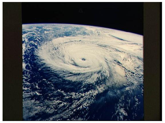
Hurricane Mitch

Hurricane Mitch was one of the deadliest and most powerful hurricanes observed on record, with maximum sustained winds of 180 mph (290 km/h). The storm was the thirteenth tropical storm, ninth hurricane, and third major hurricane of the 1998 Atlantic hurricane season. At the time, Mitch was the strongest Atlantic hurricane ever observed in the month of October, though it has since been surpassed by Hurricane Wilma of the 2005 season. The hurricane also tied for the fourth most intense Atlantic hurricane in recorded history, but it has since dropped to seventh.
Mitch formed in the western Caribbean Sea on October 22, and after drifting through extremely favorable conditions, it rapidly strengthened to peak at Category 5 status, the highest possible rating on the Saffir-Simpson Hurricane Scale. After drifting southwestward and weakening, the hurricane hit Honduras as a minimal hurricane. It drifted through Central America, reformed in the Bay of Campeche, and ultimately struck Florida as a strong tropical storm.
Due to its slow motion from October 29 to November 3, Hurricane Mitch dropped historic amounts of rainfall in Honduras and Nicaragua, with unofficial reports of up to 75 inches (1900 mm). Deaths due to catastrophic flooding made it the second deadliest Atlantic hurricane in history; nearly 11,000 people were killed with over 8,000 left missing by the end of 1998. The flooding caused extreme damage, estimated at over $5 billion (1998 USD, $6 billion 2006 USD). Hurricane Mitch was the deadliest Atlantic hurricane since the Great Hurricane of 1780, displacing the Galveston Hurricane of 1900 as the second-deadliest on record. Nearly eleven thousand people were confirmed dead, and almost as many reported missing. Deaths were mostly from flooding and mudslides in Central America, where the slow-moving hurricane and then tropical storm dropped nearly 3 feet (900 mm) of rain. The flooding and mudslides damaged or destroyed tens of thousands of homes, with total damage amounting to over $5 billion (1998 USD, $6 billion 2006 USD), most of which was in Honduras and Nicaragua.

(from Wikepedia). The DVD clip shown in the lesson is from the 'Wild Weather' series.
Tropical Cyclone Favio hits Mozambique

It arrived at about 2 hours after the time predicted on Wednesday!
Cyclone Favio made landfall in the central province of Inhambane near the town of Vilanculos and is heading inland towards the city of Beira.
Winds are reported to be in the range of 100mph-130mph (160km/h-200km/h).
The country is still struggling to cope with the effects of recent floods. An estimated 120,000 Mozambicans have already been driven from their homes.
Winds are reported to be in the range of 100mph-130mph (160km/h-200km/h).
The country is still struggling to cope with the effects of recent floods. An estimated 120,000 Mozambicans have already been driven from their homes.
Further details can be found in the report on the BBC news website.
Tuesday, 20 February 2007
Hurricane
In Wednesdays lesson we will review your notes and understanding on a) Formation of Tropical Storms b) The events & impact of Hurricane Katrina & c) The management of Hurricane Katrina. We will then contrast this with the events, impact and management of a tropical storm in an LEDC. Please make sure that your ILA is complete.
Thursday, 8 February 2007
Thinking of A level Geography (I hope!)?
You might like to have a look at the A2 Geography blog. It is slightly different from this blog as the students post as well as me, using it to share their observations & research, as well as to ask questions. Its only as old as this site & spans two module exams (Managing Wilderness & the Synoptic paper). We are currently completing the Ecosystem section of the Global Challenge unit, looking at management issues. Resources used for the lesson, such as PowerPoints, are avaialable via 4 shared.com, in the same way as I have done on this blog. I intend to use the same format for an AS geography blog next year (I will probably still use the Geography Room name).
Wednesday, 7 February 2007
What causes a hurricane?
This website gives a neat summary of the causes of a hurricane & provides other potentially useful links. Don't forget to make good notes on the causes & development of a hurricane. If you find additional websites that you think will help other students in the group, then you could post them in the comments section of this post.
Tuesday, 6 February 2007
Hurricane Katrina

Wednesday's lesson will introduce storm hazards by examining the tragic events around Hurricane Katrina. The introductory PowerPoint can be downloaded from here and you can also find 'The New Battle of New Orleans' by clicking on the link. There are also a couple of good tribute films on U-Tube. Have a look. The main PowerPoint can also be downloaded from 4 shared.com. The music is a Hurricane Katrina remix called 'DHT Listen to your heart'. Its more poignant than 'the new battle of New Orleans'! It also covers many of the key facts about Hurricane Katrina. Ideal for the audio learners amongst you!
How weird is that? I have just looked up from my laptop & on TV is an item about when Hurricane Mitch hit Honduras! This was another category 5 hurricane. The programme is 'Wild Weather' which is (hopefully) recording. I suppose that as the title of the programme is 'Wild Weather' its not too surprising that hurricanes get a mention, but that it was just as I was typing this post..... It seems a good programme -should span the Natural Hazards module into the Natural World/ Weather section that we need to do inorder to complete the course!
I hope that you have all completed your 'expert' cards!
The results afternoon seemed to go really well. I hope you all enjoyed it & that it struck the right note. There is everything to play for but the next 3 1/2 months are crucial!
Monday, 5 February 2007
http://www.geogdocs.co.uk/

This new site will show you how to use 'movie maker' to make your own geogdocs that will no doubt be better than mine! Movie maker is packaged with Windows XP so you probably already have it. It is easy to use & produces some fantastic revision resources. Making movies is an excellent 'whole brain' learning activity & it pushes all of the VAK buttons. It even gives you a list of copyright free music sources to check out! Hopefully we will use this in class but don't wait for that, have a go!
Tuesday, 30 January 2007
Wednesday 31st January

Sorry that I am missing today's lesson. You will have an opportunity to complete your 'expert cards' for topics covered in the trial exams & to otherwise 'dot the i's & cross the t's'. There will be paper cards available & 'virtual' ones can be found on the previous post. If you look on the latest posts on the Geobytes blog you will find some fantastic resources on earthquakes -you could use San Fransisco as an MEDC example (instead of Kobe). It was featured on the 'Ring of Fire' DVD that you watched at the beginning of the unit. Friday pd 3 is planner period so see you next week! If you have any questions, just post them as 'comments' on this post & I will get back to you as quickly as I can.
Sunday, 28 January 2007
Expert cards
If you wish to make additional 'expert cards' or produce them on the PC, you can download the Publisher document from here. If you do not have Publisher then there are copies on this powerpoint, plus a list of the 'expert cards' needed for the trial exam material. Please make sure that you complete the cards correctly & in an appropriate amount of detail.
Tuesday, 23 January 2007
feedback ready!
Expect to receive detailed feedback on both papers & to take action! Please bring all exercise books & textbook to the lesson.
Friday, 19 January 2007
Wednesday, 17 January 2007
Paper 2!
The final words of wisdom....... watch the time! Assume 20 minutes reading & planning the 1 mark per minute! 4 mark bit.... 4 minutes, 9 marks..... 9 minutes! Make sure that your language is precise & that you use the correct case studies. Read back over the 'command words' post & the Paper 2 case studies post. Rehearse the key details & check that you know what they are examples of! Do the questions we have studied i.e. Managing hazards & Managing Tourism! Do NOT attempt the other two questions!!!!!! Good Luck to you all!
Saturday, 13 January 2007
From the examiners report... about case studies.
This is a quote from the Examiners Report for the 2006 June Exam for paper 3H (Paper 1, Higher tier): "
The examiner states "A typical C candidate would be expected to write several level two responses for Q1(d), Q2(c), Q4(b)(iii) and Q4(d) but it was my experience that this was not often the case. Many of the answers are very general without any specific case study material andhave remained at level one even when their theory has been good." The examiner goes on to write "Similarly the typical A candidate would be expected to write several level three responses but this is not always the case."
I have been careful to teach & highlight the case studies required in the specification. Make sure that you recognise the opportunities to use this knowledge & understanding. You will have seen this school based GCSE site during lessons. If you click here it will take you to their revision site, which is great (wish I could do this-but at least I found it!). This will remind you again where the case studies are & give you some additional material to help you review your learning.
Friday, 12 January 2007
Rio de Janerio

We spent quite a while today reviewing the patterns of land use in an MEDC city, especially in relation to Leeds but made little reference to Rio de Janeiro as the LEDC case study. Whilst revising Rio you may want to look at the Wikepedia entry for Rio & to follow the link to Favelas. It is pretty good on the different zones within Rio although lacks a detailed map.
Subscribe to:
Comments (Atom)
Must have a map!
